LC 00117: verschil tussen versies
Geen bewerkingssamenvatting |
Geen bewerkingssamenvatting |
||
| Regel 1: | Regel 1: | ||
By looking at the activities, actors and methods | By looking at the the activities, actors and methods or approaches used, this section will provide a better understanding of the implementation process of the MLS approach. We will describe the point of departure, who was involved (when, why and how) and what key decisions were made when and why. | ||
=== Point of departure of FRM strategies === | === Point of departure of FRM strategies === | ||
| Regel 7: | Regel 7: | ||
[[Bestand:Web Medway.png|gecentreerd|miniatuur|500x500px]] | [[Bestand:Web Medway.png|gecentreerd|miniatuur|500x500px]] | ||
''Figure 1: Current and desired score to reach per layer in this pilot ({{Cite|resource=Bestand:FRAMES Monitoring Survey 14 Medway SERT FINAL.pdf|name=Baseline monitor Medway, 2019|dialog=process-file-dialog}}).'' | |||
=== Stakeholders involved === | === Stakeholders involved === | ||
| Regel 58: | Regel 58: | ||
Community Engagement is considered essential for the project. Not only are communities best placed to understand the problems of flooding in their area, their support for NFM is a contribution to reducing flood risk and vital to the long-term prospects of NFM. They are also have an important role as advocates for the project on a local level, and developing good relationships with the many private landowners with whom we need to work to deliver projects on the ground. Initially, the pilot area was to be a neighbouring catchment but due to a number of factors including other funding being obtained to focus separate NFM work on that catchment, and the opportunity of that the establishment of the Medway Flood Partnership presented, meant that the pilot area was moved to the Medway in the early stages of the project. This required a considerable effort to identify, and to build and nurture new relationships with key community leaders and landowners in the target areas. | Community Engagement is considered essential for the project. Not only are communities best placed to understand the problems of flooding in their area, their support for NFM is a contribution to reducing flood risk and vital to the long-term prospects of NFM. They are also have an important role as advocates for the project on a local level, and developing good relationships with the many private landowners with whom we need to work to deliver projects on the ground. Initially, the pilot area was to be a neighbouring catchment but due to a number of factors including other funding being obtained to focus separate NFM work on that catchment, and the opportunity of that the establishment of the Medway Flood Partnership presented, meant that the pilot area was moved to the Medway in the early stages of the project. This required a considerable effort to identify, and to build and nurture new relationships with key community leaders and landowners in the target areas. | ||
SERT works closely with FRAMES partner the National Flood Forum in developing links with local flood action groups and parish councils. We now have strong links with Headcorn Parish Council and its flood action group, | SERT works closely with FRAMES partner the National Flood Forum in developing links with local flood action groups and parish councils. We now have strong links with Headcorn Parish Council and its flood action group, a | ||
nd also the Flood Wardenf | |||
'''''All photos by courtesy of Dean Morrison (South East River Trust).''''' | '''''All photos by courtesy of Dean Morrison (South East River Trust).''''' | ||
Versie van 30 jun 2020 15:53
By looking at the the activities, actors and methods or approaches used, this section will provide a better understanding of the implementation process of the MLS approach. We will describe the point of departure, who was involved (when, why and how) and what key decisions were made when and why.
Point of departure of FRM strategies
The area is dominated by impervious clay soils on the high ground of the ‘High Weald’ which at times of heavy rainfall rapidly drain onto the lower lying land of the Low Weald. The ‘Greensand Ridge’ forms a geomorphological barrier to flow of water to the sea, and has created a large basin to the south of it where many settlements suffer fluvial flood risk, such as the town of Tonbridge and villages such as Yalding. Historically these settlements grew around strategic crossing points of the rivers. The historic core of most of them was constructed on higher ground, however as they expanded due to population growth many properties were built on land prone to flooding. In addition many smaller communities, such as Headcorn and Five Oak Green, are at risk of surface flooding from excessive local rainfall events in smaller sub-catchments. Often these communities are at risk from a combination of both fluvial and pluvial flooding, exacerbated with inadequate and outdated drainage infrastructure.
Rapid population growth from the 1920’s to present led to the construction of many newer buildings located in areas of flood risk, and in recent years climate change seems to be contributing to more extreme rainfall events interspersed by longer periods of drought.
Figure 1: Current and desired score to reach per layer in this pilot (Baseline monitor Medway, 2019).
Stakeholders involved
The Medway Flood Partnership NFM steering group is formed by the following actors:
- South East Rivers Trust (SERT)
- Environment Agency (EA)
- National Flood Forum (NFF)
- Kent County Council (KCC) - Lead Local Flood Authority
- Kent County Council Highways department
- Maidstone Borough Council
- Sevenoaks District Council
- Tonbridge and Malling Borough Council
- Tunbridge Wells Borough Council
- Upper Medway Internal Drainage Board
- Southern Water Services Limited
- South East Water
- Natural England
- Forestry England
- National Farmers Union
- Country Land and Business Association
- Medway Catchment Partnership
In addition through the NFM pilot, we have expanded our collaboration and now work with the following stakeholders and supporters of the project:
- Hadlow Estate
- National Trust
- Royal Society for the Protection of Birds (RSPB)
- Headcorn Parish Council
- Capel Parish Council (Five Oak Green)
- The Conservation Volunteers
- King's College London
- Ambios (Nature conservation training and research enterprise)
- Seven individual landowners and farm enterprises
- Local drainage contractors
- Local woodland contractors
- Local ecological and archaeological surveyors
Role of key actors
- The South East Rivers Trust leads this pilot in Medway and coodinates NFM delivery for the Medway Flood Partnership (MFP) through its role as the secretariat of the NFM Steering Group for the MFP. It receives match funding from the Environment Agency, and close support from the Environment Agency Medway NFM project coordinator.
- SERT employs a Project Officer to develop and deliver local relationships and partnerships, supported by a Technical and Monitoring officer and a Project Manager. Further technical and delivery support is given by the SERT Operations Manager and the wider team.
- There are monthly NFM Project Board Meetings between representatives of SERT and the Environment Agency, and tri-annual meetings of the wider partnership at Medway NFM Steering Group meetings. The rpoject is discussed at the regular Medway Catchment Partnership meetings. Bilateral meetings with key partner such as Forestry England, the National Trust, RSPB, South East Water, as well as private landowners are frequent.
- The SERT Project Officer also engages with other NFM projects across the UK in order to keep abreast of the latest developments in the field, and to share best practice.
Main activities
Identification of the target areas to implement NFM measures
On the basis of high level NFM opportunity mapping for the UK, plus input from local staff and stakeholders, the EA developed a business case for NFM in the Medway, which identified opportunities at sites such as Bedgebury and Sissinghurst. This formed the basis for implentation at a local level. A ’co-design’ approach was taken, and further research (including ’Scimap modelling of flow pathways at a fine scale) and consultation at a local level identified a number of priority sub-catchments within the Medway. These were selected on the basis of their potential to provide benefits for local communities in the near term. Through a series of workshops and meetings of the NFM Steering Group the Alder Stream and School Stream sub-catchments were selected as priority areas for SERT delivery of NFM works. These were designed to help the communities of Five Oak Green and Headcorn respectively. In a coordinated approach, partners such as the Kent Countryside Management Projects adopted other sub-catchments such as the Busty Stream and Somerhill Stream as their priorities. In addition two ’demonstration sites’ were selected as places where exemplar projects could be developed in order to disseminate knowledge and best practice in NFM, as well as providing longer-term benefits to the catchment as a whole.
SERT developed a Project Execution Plan (SERT, 2018) for the NFM Steering Group partners for the implementation of the NFM intervention in the Medway catchment. The NFM steering group meets three times a year to coordinate this work, to discuss priorities, and to track progress. It reports to the high level Medway Flood Partnership Strategy Group which oversees the implementation of the Medway Flood Action Plan as a whole.
Community engagement
Community Engagement is considered essential for the project. Not only are communities best placed to understand the problems of flooding in their area, their support for NFM is a contribution to reducing flood risk and vital to the long-term prospects of NFM. They are also have an important role as advocates for the project on a local level, and developing good relationships with the many private landowners with whom we need to work to deliver projects on the ground. Initially, the pilot area was to be a neighbouring catchment but due to a number of factors including other funding being obtained to focus separate NFM work on that catchment, and the opportunity of that the establishment of the Medway Flood Partnership presented, meant that the pilot area was moved to the Medway in the early stages of the project. This required a considerable effort to identify, and to build and nurture new relationships with key community leaders and landowners in the target areas.
SERT works closely with FRAMES partner the National Flood Forum in developing links with local flood action groups and parish councils. We now have strong links with Headcorn Parish Council and its flood action group, a
nd also the Flood Wardenf All photos by courtesy of Dean Morrison (South East River Trust).
All photos with courtesy of Dean Morrison of the South East River Trust.
[All photos courtesy of Dean Morrisson of the South East River Trust.] or Five Oak Green. We have also developed good relationships with many private landowners in the area, who are generously offering their support to the project. We have also involved many volunteers in the implementation of the project with the assistance of the Biodiversity Action Team of The Conservation Volunteers.
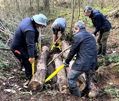
Figure 1: Volunteers from The Conservation Volunteers are installing a Leaky Woody Structure at Bedgebury.
Implementation of the NFM interventions
Alder Stream priority sub-catchment (Five Oak Green)
The Alder Stream is a small (c.8 km2) sub-catchment in a steep-sided wooded valley. The geology consists of the heavy Wadhurst Clay, overlain by Tunbridge Wells Sandstone which is a minor aquifer and generates many springs. The Alder Stream has been responsible for many serious flood events in the village of Five Oak Green downstream, with over 100 properties being at risk. Historically the Environment Agency have investigated a number of engineering solutions in an attempt to improve the situation, however these have been rejected on the grounds of impracticality or cost. Some improvements have been made to the stream grading where the stream passes through the village, along with improvements to the drainage system which have alleviated the problem to some extent. However the potential for NFM to offer further cost-effective mitigation was identified by the EA and the NFM Steering Group based on the catchment scale and wooded nature. The greatest opportunities are for the creation of leaky woody structures in the watercourse, along with the restoration of riparian woodlands. These are currently overgrazed by cattle, which destroy surface vegetation, thereby reducing surface roughness and infiltration, and compacting underlying soils.
We now have a number of supportive landowners in the sub-catchment, notably the Hadlow Estate and their leaseholder the Royal Society for the Protection of Birds (RSPB), and the manager of Reeds Farm. Work to install large woody structures and to fence 7 hectares of riparian woodland from grazing animals was completed in May 2020. As well as reducing flood risk these projects will have very positive benefits for biodiversity, in particular in the protection of species-rich ancient woodland and improved conditions for rare bryophytes. We have developed a good relationship with the flood warden from Five Oak Green who fully supports the project. Communities within the catchment experienced flooding in the exceptional winter storms of February 2020. We worked closely with these communities to provide practical support during these events. This also helped us to identify particular problem areas directly implicated as the cause of local flooding, and we are now working with our partners to develop Natural Flood Management solutions to these.
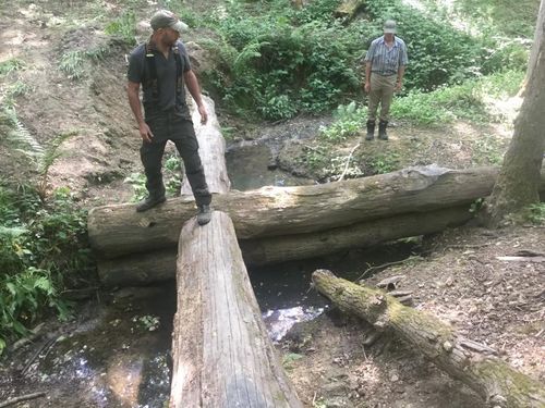
Figure 2: leaky woody structure at Reeds Farm.
School Stream priority sub-catchment (Headcorn)
The School Stream is a sub-catchment of 9 km2 to the north of the village of Headcorn. The underlying geology is mainly of the Weald Clay formation, a very heavy impervious soil. It consists of a mixture of arable and pasture land, with streamside woodlands. Local rainfall events can cause it to rise very rapidly, often with very little warning, and regularly causes flooding to a number of properties in Headcorn. These events usually occur so rapidly they are not picked up by the Environment Agency’s flood warning system, and by the time a flood warning is issued the event has already occurred. This makes an NFM approach which slows the flow and temporarily stores water in the catchment particularly suitable for this sub-catchment.
We have developed a strong relationship with Headcorn Parish Council and its flood committee, and have secured the generous agreement of a number of private landowners in the area. The main opportunities are to create Leaky Woody Structures within watercourses, as well as to create a temporary flood storage area on the site of a former pond.
Work on the flood storage area was completed in January 2020, with work on the Leaky Woody Structures also completed in April 2020.
Sissinghurst Castle Gardens Demonstration Project (with the National Trust)
SERT has been working closely with the National Trust on a range of NFM measures at their world-renowned Sissinghurst Castle Garden Estate in Kent. These include installation of Leaky Woody Structures and manmade ’Beaver Dams’ along with the restoration of a water meadow to include a flood attenuation area of 2500 m3 (Frogmead Meadow). The National Trust property recieves in the region of 200,000 visitors a year, making this an ideal location as a demonstration site, and a hub for the dissemination of expertise in NFM. The project is designed to have considerable ecological as well as flood benefits. The site is located alongside the Hammer Stream, which flows down to Headcorn, the River Buelt, and the Medway. Work was completed on the construction of the attenuation area in September 2019.
Initial monitoring results from the flood storage area are encouraging, with the system being tested by a number of exceptional rainfall events in December 2019 and January and February 2020. These show a rapid rise in water levels in the system at times of peak flow, followed by a slow release back into the river over a number of days.
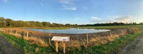
Figure 3: flood storage area at Sissinghurst.
Bedgebury Forest Demonstration Project (with Forestry England)
Bedgebury Forest is a publicly owned estate of 10.5 km2 in the south of Kent managed by Forestry England. It was formerly ancient deciduous woodland which was converted to commercial conifer plantation after 1945, but which is now managed largely for public amenity and biodiversity. The area includes the famous Bedgebury National Pinetum which attracts around 270,000 visitors a year. It was identified at an early stage by the EA as a potential NFM site due to its position on the headwaters of the Teise and the support of the Forestry Commission and Forestry England for a pilot project there. It is especially suitable for an NFM demonstration site due to its large area, many woodland streams, the opportunity to test different designs of Leaky Woody Structures, and its potential as a hub for upskilling the woodland sector in the field of NFM.
Work commenced on the site in autumn 2018, and most of the work to date has been conducted by volunteers from The Conservation Volunteers. Approximately 60 leaky Woody Structures have been created, along with a woodland flood storage area of approximately 500 m2 . The effectiveness of the structures is being monitored with the support of Kings College London and their partner Ambios.
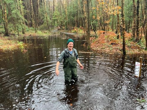
Figure 4: Flood storage area at Bedgebury forest.


