LC 00216: verschil tussen versies
Geen bewerkingssamenvatting |
Geen bewerkingssamenvatting |
||
| Regel 1: | Regel 1: | ||
=== Area description === | |||
The province of Zeeland lies in the southwest of the Netherlands with a total area of 293,000 hectares (<sup>2</sup>/<sub>3</sub> land and <sup>1</sup>/<sub>3</sub> water) and a total population of 380.000 people ({{Cite|resource=Bestand:Frames Pilotbook mei19.pdf|name=FRAMES pilotbook, 2019|dialog=process-file-dialog}}). | |||
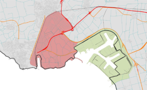
[[Bestand:Sloe area.png|gecentreerd|miniatuur|A map of the Sloe area in Zeeland, the Netherlands. The red area is Ritthem, the green area is Sloe.]] | |||
The so-called bathtub Ritthem is protected by primary flood defenses and includes the following districts: Mortiere, Dauwendaele, Magistraatwijk/Reijershove, Veldzicht, Essenvelt, Erasmuswijk (with a total of 15.500 citizens), Groot Abeele (2.000 citizens), Oost-Souburg (8.000 citizens) and Ritthem (600 citizens). | |||
The Sloe is a harbor/industrial area with 10 companies, and protected by primary flood defenses because it is situated on a high level around +5,20 NAP and seen as a rather safe area. But in case of a flooding, the area might be flooded (<sup>+</sup>/<sub>-</sub> 30 cm) ({{Cite|resource=Bestand:FRAMES Monitoring Survey 8 Zeeland Sloegebied Completed.pdf|name=Baseline monitor Sloegebied, 2017|dialog=process-file-dialog}}). | |||
=== Flood risks === | |||
With regard to flood scenarios, a distinction can be made between less extreme situations (up to once every 1,000 years) in which only flooding occurs in the Sloe area, and more extreme situations in which there is a real risk of flooding of the bathtub Ritthem. In particular, these more extreme situations are relevant for the preparation and implementation of crisis management because this is when the Sloe area will also flood. | |||
{{Light Context | {{Light Context | ||
|Supercontext=FR PLT PR 00003 | |Supercontext=FR PLT PR 00003 | ||
Versie van 27 nov 2019 14:16
Area description
The province of Zeeland lies in the southwest of the Netherlands with a total area of 293,000 hectares (2/3 land and 1/3 water) and a total population of 380.000 people (FRAMES pilotbook, 2019).
The so-called bathtub Ritthem is protected by primary flood defenses and includes the following districts: Mortiere, Dauwendaele, Magistraatwijk/Reijershove, Veldzicht, Essenvelt, Erasmuswijk (with a total of 15.500 citizens), Groot Abeele (2.000 citizens), Oost-Souburg (8.000 citizens) and Ritthem (600 citizens).
The Sloe is a harbor/industrial area with 10 companies, and protected by primary flood defenses because it is situated on a high level around +5,20 NAP and seen as a rather safe area. But in case of a flooding, the area might be flooded (+/- 30 cm) (Baseline monitor Sloegebied, 2017).
Flood risks
With regard to flood scenarios, a distinction can be made between less extreme situations (up to once every 1,000 years) in which only flooding occurs in the Sloe area, and more extreme situations in which there is a real risk of flooding of the bathtub Ritthem. In particular, these more extreme situations are relevant for the preparation and implementation of crisis management because this is when the Sloe area will also flood.

