Implementation process
By looking at the the activities, actors and methods or approaches used, this section will provide a better understanding of the implementation process of the MLS approach. We will describe the point of departure, who was involved (when, why and how) and what key decisions were made when and why.
Point of departure of FRM strategies
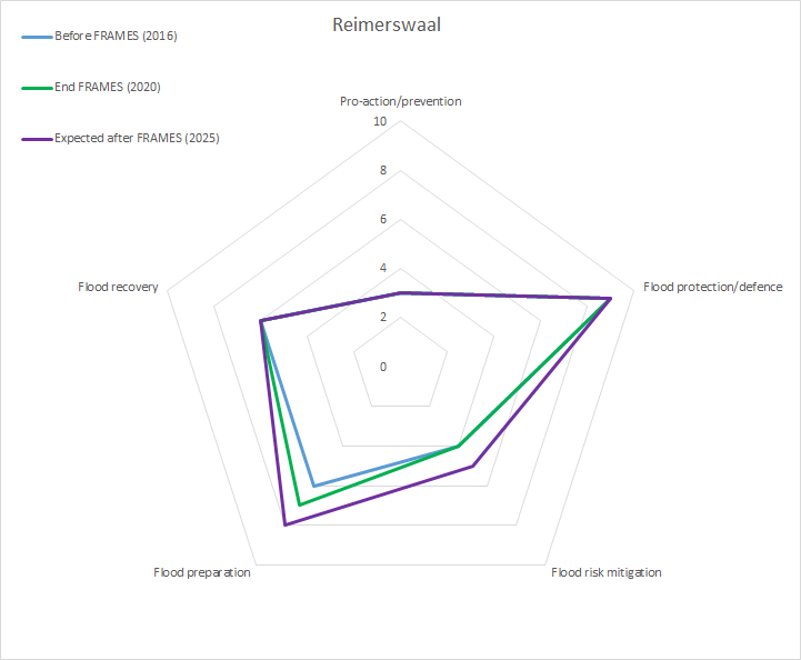
Figure 1: Current and desired score to reach per layer in the pilot (Baseline monitor, 2017). Expected scores were not given for this pilot.
To measure the impact of FRAMES on improving the flood resilience of pilot areas, communities and authorities both a baseline and final monitoring survey have been conducted. The surveys were completed by pilot managers in consultation with key pilot stakeholders. The baseline survey included questions about the actual situation in 2017 (before the project started) and expectations for 2020 (see figure 1).The final survey contained similar questions, but about the actual situation in 2020 and expected situation for 2025, five years after the pilot projects are finished. All the scores for both surveys along with can be found in chapter 8 of the Transnational Monitoring and Evaluation Report.
Stakeholders involved
- Province of Zeeland
- Rijkswaterstaat
- Waterboard Scheldestromen
- Municipality of Reimerswaal
- Veiligheidsregio Zeeland (Safety region Zeeland)
- HZ University of Applied Sciences
- Owners critical infrastructure (gas, water, railway:Prorail, highway, electricity: Enduris, communication)
Role of key actors
The Ministry of Infrastructure & Water Management and the Waterboard Scheldestromen are responsible for the first layer. The Veiligheidsregio Zeeland has evacuation plans (layer 3), but this layer is also the responsibility of Rijkswaterstaat, because they have to protect the highway while Prorail has to protect the railways. When possible, the Province of Zeeland is responsible for the second layer (interview with pilot manager, 2019).
The role of the Province of Zeeland, the pilot manager, is to give policy advise on the topic to the regional and national government. The role of the vital infrastructure owners is to provide information about the functionality and location of the assets. The Safety region is the expert on water safety in the Netherlands and hence a very important actor because they provided a knowledge, experience and a large network of relevant actors in the water safety sector for the entire country (interview with pilot manager, 2019).
Main activities
The main activities/steps carried out towards improved FRM strategies, the tools applied and the actors involved are the followings:
- Get acquainted with the area (description of the area, stakeholders analysis). The province contacted all vital infrastructure owners to discuss the problems and the possible solutions. Once the problem was clear, the rest of stakeholders were involved (vital infrastructure owners, regional government, knowledge institutes, the municipality of Reimerswaal, the safety region, the water board and the Ministry of infrastructure & Water Management). It was hard to get involved stakeholders from private companies, such as Prorail. Vital infrastructure owners and the safety region are the most important actors of the project. The actors met individually, in small groups at a round table discussion, or large groups in workshops.
- Get the geodata of the electricity grid assets. The Province of Zeeland contacted (via phone, emails, meetings) the vital infrastructure owners to discuss about the flood risks and reach an agreement to keep this data confidential providing only a code number.
- Vulnerability analysis. The vulnerability analysis of adaptive critical infrastructure (roads, rail, electricity) and the cascading effects use done by Witteveen + Bos (on behalf of Province Zeeland) in collaboration with the RAAK project. They did flood simulations of 30 asset points using GIS models and the location of vital infrastructure. Vitale Assets tool from HZ University of Applied Sciences was used to analyse impact of flood scenarios on critical infrastructure and the Circle tool from Deltares was used to identify the cascade-effects.
- Proposed spatial measures (to be completed based on report). Witteveen + Bos and Ecorys are conducting a cost-benefit analysis of potential spatial measures. The costs of the spatial measures proposed for layer 2 (build an inner dyke to prevent highway and railway from flooding) may be more expensive (about $45 million ) than measures in layer 1. Moreover, they may require longer implementation time.

